Archive for the ‘Trails’ Category

Mother Nature doesn’t care if you’re having fun.
– Larry Niven

This wasn’t part of the plan.

Actually, the steady uphill jog on nice wide dirt trail was the plan, the reason I was here.  But freezing temperatures? Near-blizzard conditions?  And a disturbingly cold headwind that was – almost scornfully – treating my rain-soaked body like high-school football players treat one of those paper banners that cheerleaders hold up at the beginning of games? Using the ten fingersicles on the ends of my arms as blunt-force instruments, I brutishly hammered out a text to let Katie and Chuck know I was halving my intended 8-mile ascent and turning around.  This was turning out to be a typical winter run in our Midwestern United States.

Except this wasn’t the Midwest… this was Southern California.  Orange County, to be exact.  Average yearly snowfall of zero inches.  And that’s rounding up.

Maybe this would be my comeuppance for shrugging off both the Mayans and Weather.com


Maybe this day would be my comeuppance for shrugging off both the Mayans and Weather.com

So I could hardly be blamed for finding myself in a driving snowstorm, wearing my usual comfortable winter running gear of t-shirt and shorts.  And the finishing touch – the coup de grâce in this absurd comedy of errors – was the bottle of cold coconut water that now threatened to drain all remaining feeling from the fingers wrapped tightly around it.

It was only natural to ask how this had happened.  Much as I wanted to, I couldn’t really blame my brother for this one.  True, it was Chuck who had – after careful consideration – recommended I run the Harding Truck Trail to Modjeska Peak during our New Year’s visit to SoCal.  And the elevation profile from his Garmin had sealed the deal, showing a daunting route that began at ~1,400ft and summited 12 miles later at ~5,400ft, making Modjeska second only to its next-door neighbor Santiago as the highest peak in Orange County.  How could I refuse an offer like that, with an ascent unavailable in the Bay Area?  And so, begrudgingly, I let Chuck off the hook.

Certainly The Weather Channel had steered me wrong.  Moments before we’d hit the road for Modjeska, I’d checked Weather.com and found a forecast of low 50s and a 10% chance of precipitation for the area around Modjeska Canyon.  And even if I were to get wet out on the trail, no worries… I’d just managed eight miles in a steady SoCal downpour 24 hours earlier, and in the process gained a front-row seat to a magnificent full (and near-double) rainbow stretching from Laguna Niguel to Dana Point.  I could almost hear the leprechauns on each end frolicking in their piles of gold coins.  Plus, I’d maintained a respectable pace on slick sidewalks.  So more rain wasn’t a concern, despite the mud it would generate.

But driving snow?  No, this definitely wasn’t part of the plan.

The splice is twice as nice: even my low-res cell phone camera couldn't spoil this iridescent display

The splice is twice as nice: even my low-res cell phone camera couldn’t spoil this iridescent display

I’m not the superstitious type, but maybe simple karma was to blame here.  After Amy recently wrote about her winter training in Albuquerque, I’d joked that as a Californian I enjoyed “hearing other people’s stories of training in cold weather, without being able to relate in any way.”  So maybe I’d brought this on myself – a (literally) cold (literally) hard lesson in winter-weather empathy.

But let me rewind a bit: last Sunday seemed like any other characteristically mild winter day in SoCal, as Katie and I made the 20-mile drive out to Modjeska Canyon.  Approaching our destination, I realized I’d forgotten my water bottle, so we made a brief pitstop to buy cold coconut water.  A surprisingly sharp chill greeted us as we stepped out of the car, intensified by a monochromatic gray sky that overpowered the usual Orange County sunshine.  Meanwhile, our car’s “outdoor temp” display read a balmy 55°.  Ideal winter running weather.

We met Chuck and Laura at the Tucker Wildlife Sanctuary, at the foot of Modjeska Peak.  Conveniently (for him), Chuck was nursing an injured hamstring, so Laura and I would be running this one by ourselves.  In the men’s room hung a sign announcing the park’s recent loss of state funding, and imploring the reader to bring extra toilet paper, paper towels and hand soap with them to share on their next visit.  Ah, California… the golden beholden state.

Mike Sohaskey and Laura running in Modjeska Canyon

Off to a good start – if only the sky in front of us had stayed this gloriously drab
(photo by Chuck, without whom I’d be pulling random images off Google)

The warning chill in the air prompted me to pull on my arm sleeves – my usual ample protection against the California winter.  As Laura and I trotted toward the dirt to start our immediate ascent on the Harding Truck Trail, a gray-bearded fellow in a faded baseball cap leaned out the window of his pickup truck, smiled and declared “You’re just in time for the rain!”  Though the skies remained bleak the air remained dry, and I smiled back absentmindedly as we trotted on without a second thought.  Dirt or not, it wasn’t like me and my trusty Mix Masters couldn’t handle a bit of rain.

With no level-ground opportunity to warm up my legs and lungs, I acclimated to the ascent by jogging alongside Laura for the first few minutes.  Chuck awaited us at the ¼-mile mark with camera in hand.  Laura and I chatted and set expectations: since she hoped to run a low-key New Year’s Eve marathon the next day, her goal on this day was ten miles (five up, five down).  Despite our late start, I was aiming to cover 16 miles (eight up, eight down) and experience as much of the trail as possible on my first outing.  So Laura would most likely be done and gone by the time I found my way back to where Katie awaited at the wildlife sanctuary.

At the ¾-mile mark I picked up my pace and pulled ahead of Laura – I’m more of an uphiller, she’s more of a down-hiller, as I’d be reminded later.  I was eager to tackle the trail and find out how it stacked up against my favorite Bay Area hills.  Ironic that my main concern at the start of this run – the persistent ascent – would quickly become my least.

Mike Sohaskey running Harding Truck Trail

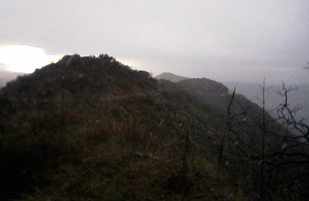
Trail Running for Dummies: Don’t keep going when the sky ahead of you looks like this
(photo by Chuck, who no doubt made a beeline for his car right after this was taken)

At the one-mile mark the course’s uphill trajectory gives way to a brief ¼-mile downhill jag.  Here I further increased my pace and fell into a comfortable rhythm.  Bounding along I had the trail more or less to myself, and I planned to savor my light-footed feeling before the coming uphill grind took its toll.  The previous day’s showers had softened the dirt just enough to provide optimal footing – not too dusty, not too muddy, with just the right combination of firmness and tack.

Glancing up and ahead of me, I noticed for the first time that the light-gray clouds had yielded to a dark, ominous haze that now engulfed Saddleback Mountain – comprising Modjeska and Santiago Peaks – and which threatened to swallow all remaining light.  Suddenly my surroundings looked like a Photoshop creation, as though someone had applied a “Middle-earth” filter to the scene: had I left Orange County and entered the Misty Mountains?

My first sense that a light mist had begun to fall was the tiny droplets that splashed against my sunglasses and merged into a watery film (yes, sunglasses, I was naïvely confident that the sun would eventually break through the clouds… hey, this was Orange County!).  As the trail wound its way upward, I periodically rounded a corner and found myself running into a brisk headwind.  Wind is hands- (and heads-) down my least favorite part of running, but fortunately this was relatively mild and only minimally impeded my progress.

Not as impressive as Chuck's

Not as impressive as Chuck’s 24-mile elevation profile, but I’ll be back to finish the job

As my Garmin chimed to signal the end of mile two, the mist gradually transitioned into legitimate rain, and now each turn seemed to greet me with a colder and more powerful gust than the one before.  The wind began to change direction erratically, blowing the rain diagonally as though searching for the most efficient way to ensure my discomfort.  Wind and rain continued to build in intensity as my Garmin signaled the end of mile three.  And moments later, things got (d)icy…

Maybe it was my focus on pushing forward up the trail.  More likely it was the incongruity of snow in Southern California (and below 3,000ft at that).  In any case I failed to register the first few snowflakes drifting around me, until at last my eyes synced with my brain, jarring me back to reality.  Sure I’d realized the temperature had been dropping steadily as I’d ascended out of Modjeska Canyon… but shortly before mile three I would’ve pegged it at mid- to high 40s, maybe low 40s with wind chill.  Now, watching the first airborne snow I’d ever seen in Southern California, it was clear Mother Nature had upped the ante.

Always the optimistic/stubborn runner, I persuaded my brain that: 1) snow was preferable to rain for its consistency; 2) having run only three miles, I couldn’t turn back now; and 3) this was my golden opportunity for a winter wonderland run in the snow, having been denied in Dallas six days earlier when a vigorous Christmas snowfall had followed a freezing rainstorm that coated sidewalks and streets with a thin layer of ice.  As I embraced my questionable decision-making and pressed onward toward Modjeska Peak, I did make one allowance for the weather and my soggy state, electing to truncate my run to 12 miles (six up, six down) rather than the intended 16.  That way I’d likely catch Laura on my way down as well.

snow on modjeska

Not bad, actually, for a photo of falling snow taken with frozen fingers on my tiny cell phone camera

But my expectations for this day took a final nosedive as I reached the 3.5-mile mark and the snowfall intensified to – I cannot tell a lie – blizzard proportions.  Like a swarm of fluffy white bees attacking my face and body, the swirling snow rode the wind currents downward from the dual peaks of Saddleback Mountain.  My primary concern quickly became the ever-increasing stiffness in my finger joints, as numbness threatened to replace all feeling at the ends of both arms.  I cursed the #@*&ing bottle of coconut water that was my faithful companion – the only thing worse than holding on it, I considered, would be dropping it.  That wasn’t going to happen, and I didn’t want to simply dump out the bottle on the trail.  So unfortunately the two of us were in this together to the bitter end.  And I was already bitter.

Somehow, despite my discomfort and the absurdity of running through a driving snowstorm in a soaked t-shirt and shorts but no gloves, I had one stupid decision left in me, and I resolved to reach mile 4 before turning around.  Blame it on mental numbness, but somehow the four-mile mark became the hard and fast limit of what I was willing to concede.  So with head down I plowed forward up the trail, swallowing snowflakes and with hands wrapped inside my t-shirt as protection against the biting wind.

I was starting to think I’d also lost feeling in my Garmin, when at last it rang out the end of both mile 4 and my uphill trek at a mere 3,113ft.  Fumbling with my phone, I awkwardly pounded out a “snowing! turning back now” text to Chuck and Katie with minimal cooperation from the semi-responsive stubs formerly known as fingers.  Then I swung a U-turn and launched myself back down the trail, gaining an immediate reprieve from the snow and wind which were now largely at my back.

Mike Sohaskey and Laura post-run

Laura and I thaw out at the Tucker Wildlife and Soggy Runner Sanctuary
(photo by a warm, dry Chuck)

Cruising downhill now, I alternated between shielding both hands in my t-shirt and beating each hand against the opposite forearm to regain feeling and keep the blood flowing, while the chilling effects of my water bottle continued to counteract my efforts.  Fortunately the descent proved smooth enough, and soon I caught up with Laura, still struggling up the trail below the snowline around mile 3.  “There you are!” she sounded relieved as she saw me squishing toward her.  Apparently she’d tried to call me after she’d run through a flurry of hail I’d somehow avoided.  Laura regularly competes in (and completes) 50-mile races, but even before reaching the snowline she was ready to turn around.  Together we covered ground quickly as I hustled to keep pace behind her dogged downhill stride.  I was surprised during our descent to have to sidestep and hurdle so many newly formed puddles and rivers; this was a much different trail than the one I’d felt so sure-footed on just an hour earlier.

Finally we reached the Tucker Wildlife Sanctuary, where we found Katie and Chuck waiting out the rain in the car.  Owing to the limited cell coverage in the canyon, neither had received my text, and both were more than a little surprised to hear we’d encountered hail and snow on trail.  Though I may have been pushing my luck when I claimed to have also seen a Bumble.

Still in my wet t-shirt and shorts (though at least I’d brought long pants to pull on over my shorts), and with my belly now full of coconut water, the four of us reconvened for a post-run snack 15 minutes later.  From the strip mall parking lot in Mission Viejo we could clearly see Modjeska and Santiago Peaks, each of which was now capped with a very fine but undeniable blanket of newborn white.  Though pleased to have my story confirmed so graphically, I was shocked to see how quickly the snow had accumulated.  The scene warmed the cockles of my – ah who am I kidding, no it didn’t… I was still shivering from the damp t-shirt and shorts that clung to me like frightened children.

Snow on the peaks

Those look like late afternoon shadows, but that’s snow on Modjeska (center) and Santiago (right)
(photo by Chuck, who then got the Snow Miser song stuck in his head)

As Saddleback Mountain receded in our rearview mirror, my phone beeped with a message from Chuck, who’d finally received my earlier text: “Snow? What idiot told you to run up a mountain?”  Unfortunately I’d been denied the long uphill run I’d planned for that day.  But I’d gladly trade a few extra miles for one of the more bizarre training runs I’ll likely ever experience, complete with rain, snow, hail, earth, wind & fire (and what a funky day it was).  All within an hour of The Happiest Place on Earth.

Based on what I saw of it, I’ve no doubt the Harding Truck Trail is tremendous running terrain on just about any other day of the year, and in fact the Harding Hustle in July has now joined my short list of potential summer races.  At which time the “fire” part of that forecast may very well come true.

In the end, the day added yet another verse to the anthem that runners (and especially trail runners) know all too well, and which author Larry Niven summarized so elegantly: Mother Nature doesn’t care if you’re having fun.  She doesn’t care if you’re too hot, or too cold, or hungry, or thirsty, or sunburned, or wind-chapped, or rain-soaked, or well nourished, or craving carbs, or fully hydrated, or chafed, or blistered, or breathless, or numb, or dressed appropriately, or chasing a PR, or lost, or trying out your brand-new trail shoes, or allergic to poison ivy, or scared of snakes, or tired of climbing hills, or roughed up after tripping headlong over a tree root, or unable to see ten feet in front of you, or physically spent, or psychologically exhausted, or a first-timer, or a seasoned veteran, or a prince, or a pauper, or out of water, or in the wrong place at the wrong time when something bigger and stronger than you gets hungry, or trapped with your arm crushed under a boulder and only a dull pocket knife between you and The End, or comfortable in any way.  She’s an equal opportunity offender, and she just doesn’t care.

Ours may be an abusive relationship, but she’s my kind of lady.

Runners have great stories, so I’m curious: what has been your most bizarre/unanticipated running experience?

Do you know about the trail that links the East Bay Regional Parks?  Have you run it?  If so, what is/are the best section(s)?
– Fellow East Bay runner (and now marathoner) Jen

Continuing on with my two-day goal of mapping a 32-mile course from Wildcat Canyon to Chabot Regional

DAY TWO (TILDEN TO CHABOT):

Arrows signify the boundary where each Regional Park/Preserve begins

Arrows signify the boundary where each Regional Park/Preserve begins

Day Two of my East Bay trail hazing adventure would begin at the 12-mile mark of last week’s run, in the parking lot of the Tilden Park Steam Trains.  Katie dropped me off amid the teeming masses of frazzled parents and unruly kids, and with full energy reserves I crossed Lomas Contadas and picked up the Bay Area Ridge Trail headed toward Sibley.  The next 11 miles passed uneventfully, and roughly two hours later I found myself back in Redwood Regional on the West Ridge Trail, looking for the turnoff to the Golden Spike Trail.

There are two distinct ways to access the Golden Spike Trail.  The first is the route I took the previous weekend to finish my run: follow the West Ridge Trail downhill to its end, cut a hard right on to the Golden Spike Trail, then follow it back uphill (sound fun yet?) and continue on your way.  I prefer the alternative route, though it can be a bit tricky because there’s no sign indicating the turnoff for the Golden Spike Trail.  Here it is: just before the West Ridge Trail takes a sharp left turn and begins its final steep descent, look for a “no bicycles” sign (i.e. a bicycle with a red diagonal line through it; see below) on the right side of the trail.  This sign acts as gatekeeper to a short-lived (~20yds long), easy-to-miss rocky connector path leading to the Golden Spike Trail.

bikes bikes bikes

Like Platform 9¾ at King’s Cross Station, this sign conceals the connector path to the Golden Spike Trail

After less than ¾-mile on the Golden Spike Trail, look for the sign indicating the turnoff to Redwood Road.  If you reach the intersection with the Toyon Trail, you’ve gone too far.  Follow this sign out to and across Redwood Road to the Big Bear Staging Area parking lot, and voilà!  You’ve just entered Anthony Chabot Regional Park.  Based on my own experience, Katie will be waiting here with a smile and a bottle of ice-cold coconut water.  Not easy to run away from, and yet I did…

Straight into the arms of the MacDonald Trail (doubling as the Bay Area Ridge Trail) and another steep ascent.  Another feature currently missing from Google Maps is the MacDonald trailhead, which begins on the left side of the Big Bear Staging Area parking lot and runs parallel to Redwood Road a short distance before passing the MacDonald Staging Area.  From there, the ~500ft of vertical gain over the next mile dragged a lot out of me, including some choice profanity, and I was relieved when the next 3+ miles into Chabot Regional were largely downhill.

Grass Valley Trail sign

Choose your own adventure (I chose left) at the junction of the MacDonald Trail and Grass Valley Trail

After ~2.75 miles the MacDonald Trail hooks up via a short connector trail with the Grass Valley Trail.  Here a two-arrowed sign (see above) gives you the option to either forge straight ahead, or swing a switchback turn to your left and continue along the unlabeled Bay Area Ridge Trail.  Take the left turn, and you’ll descend through a gate and past the Bort Meadow Staging Area, where the trail widens on its way into Chabot Regional.

The Grass Valley Trail is relatively flat and mostly exposed, though to a lesser extent than Nimitz Way.  My late-afternoon run benefitted from extensive shading, courtesy of the densely packed trees lining the western (right) side of the trail.

Grass Valley Trail

Now that thar’s a trail! The comfortably wide Grass Valley Trail, to be exact

Within 2 miles the Grass Valley Trail morphs into the Brandon Trail, another heavily used footpath that leads through Chabot Regional and to this day’s finish line ~5 miles away.  After ascending 300ft in half a mile, the Brandon Trail undulates gently for ~2 miles before starting, like moth toward bug zapper, its inexorable downward trajectory toward Redwood Road.  You’ll see your final destination sprawling below (far below, it seemed to me), before the bottom drops out and the trail descends 600 vertical feet in 1.5 miles, taking back in short order all the elevation (and then some) you’ve gained to that point.

Somewhere along this descent – I didn’t notice where – the trail splits into two separate forks of the Bay Area Ridge Trail, one of which deviates eastward along the Willow View Trail toward the Chabot Staging Area and the East Bay Municipal Utility District (EBMUD).  Unless you want to take a detour toward the enticingly named EBMUD, continue down the Brandon Trail which bottoms (and flattens) out at the Willow Park Public Golf Course.  Stay on the trail bordering the golf course, hopping or sidestepping the occasional log neatly placed across the trail, and that’ll be Redwood Road to your left.  Continuing along the Brandon Trail parallel to Redwood Road, I reached the Proctor Staging Area where this branch of the Bay Area Ridge Trail ends.  Not with a bang, but a whimper.

After 45 miles of blood, sweat and tears eyeball sweat on some of the Bay Area’s toughest trails, I could relate.

WANT MORE? To continue on from the Proctor Staging Area to the Lake Chabot Marina, follow the signs for the Lake Chabot Bicycle Loop and Ten Hills Trail south to the McGregor-George Trail; from this junction it’s less than a mile to the marina.

GEAR: For Day One of my East Bay trail tour I wore my Brooks PureCadence shoes (with 5mm heel-to-toe drop), which despite their road tread didn’t disappoint on the dirt.  For Day Two I relied on my zero-drop Merrell Road Gloves, with predictably solid results: the well-worn Road Gloves continue to ride comfortably up and down hills and on all terrain.  I appreciated their lightweight build and consistent traction, without ever lamenting their lack of a protective rock plate.

FINAL STATS:
Total distance: 21.8 miles (including planned and unplanned detours)
Total time: 4:00:43
Average pace: 11:03/mile (miles 15 and 21 @ sub-10:00/mile)
Elevation change (Garmin Connect Software): 3,277ft ascent, 4,665ft descent

Bay Area Ridge Trail - 32 miles East Bay trail running

Complete directions for my two-day East Bay trail adventure

Do you know about the trail that links the East Bay Regional Parks?  Have you run it?  If so, what is/are the best section(s)?
– Fellow East Bay runner (and now marathoner) Jen

They were mighty fine questions, this troika staring up at me from Jen’s email.  Seemingly simple and straightforward each of them, but for one not-so-small snag:

I had no answers.

As a trail runner living in the East Bay, I should have had answers.  I should have been able to rattle off the logistics of the trail system that links the East Bay, a trail system comprising the (sometimes) separate but (sometimes) equal East Bay Skyline National Trail and Bay Area Ridge Trail.  But I couldn’t.

Bay Area Ridge Trail map

Click here for more information and a larger version of this map 

So like any ignorant person not resigned to their ignorant fate, I set out to learn more about each trail.  Of course my first resource was the interwebs, where I quickly learned the Bay Area Ridge Trail is a still-under-construction, multi-use trail that after completion will span 550+ miles and encircle the Bay “offering easy access to the San Francisco Bay Area’s renowned beauty.”  It currently covers (discontinuously) over 335 scenic miles while crossing diverse landscapes.  A significant chunk of that mileage passes through my neck of the woods in the East Bay, including stretches such as Nimitz Way that I run with regularity.

Similarly to the Bay Area Ridge Trail, colorful identifiers – in this case a patriotic red white and blue “USA” logo – guide the way along the East Bay Skyline National (Skyline) Trail.  But despite frequent references to its 31-mile length on personal blogs and Regional Parks websites, the Skyline Trail remains somewhat more mystical in that it lacks (to my knowledge) an official website.  So if I wanted to dissect and better understand all 31 miles of the Skyline Trail, I’d have to do it by piecing together the available online maps.  But although having a cohesive East Bay trail map would answer a lot of questions, it wouldn’t answer them all… for that I’d have to push back from the laptop and hit the trails on foot.  A dirty job to be sure, but some lucky soul one had to do it.

Bay Area Ridge Trail and East Bay Skyline Trail badges

Keep an eye out for these familiar faces along the course

I should mention that use of the singular term “trail” in this case is grossly misleading.  Each of these trail systems consists of a series of shorter spliced-together, in some cases blink-and-you’ll-miss-’em subtrails.  Certainly the whole of each Trail is greater than the sum of its dusty parts.  But as it turns out, stringing together the Skyline Trail and the Bay Area Ridge Trail in their entirety can be a mental and (even more so) physical challenge.

Katie and I pored over the online catalog of Regional Parks maps.  We charted the tortuous path taken by each of the two major Trail systems.  And ultimately we concluded that along its 31-mile length, the Skyline Trail almost entirely overlaps the Bay Area Ridge Trail, with slight divergences in Wildcat Canyon Regional Park (where the Skyline Trail begins) and Redwood Regional Park.  Pretty straightforward, actually.  So in effect I’d be running both Trails simultaneously.  Not that this mattered, because my objective wasn’t to rigorously follow either Trail, but rather to map – subtrail by subtrail – one continuous and direct route from Wildcat Canyon to Lake Chabot, regardless of Trail affiliation.  As it happens, the Skyline/Bay Area Ridge Trail offers the shortest distance (on trails, of course) between these two points.

So my route starts at the East Bay Waldorf School in El Sobrante, just north of Wildcat Canyon Regional, before intersecting both the Skyline Trail and Bay Area Ridge Trail at different points along Nimitz Way.  It then follows the Bay Area Ridge Trail (and largely the Skyline Trail) the rest of the way, finishing at the Proctor Staging Area in Anthony Chabot Regional Park, just north of the Lake Chabot Marina.  This route should be a useful resource for Bay Area trail runners: a hilly 32-mile course on challenging yet fully runnable trails, over variably technical terrain and with plenty of narrow singletrack.

Trails, here I come!(photo from 123stitch.com)

East Bay trails, here I come!
(photo credit: 123stitch.com)

Most of this course does belong to the Bay Area Ridge Trail; however, not all subtrails along the actual course are well labeled.  And from running on multi-tentacled East Bay trails without a map or a clue, I’ve learned the hard way there’s more than one way to skin (or at least exhaust) a runner.  So I’ve documented my route below, trail by trail.  I’d recommend as handy online references the Bay Area Ridge Trail website, as well as the individual East Bay Regional Parks websites.  Google Maps too can be useful, but as I note at several points in my narrative, I wouldn’t bet my last six ounces of water on it.

Something else to be aware of: dogs are allowed off-leash in the East Bay Regional Parks.  And though this doesn’t necessarily pose a threat to runners (I’ve yet to see fangs), it’s pretty irritating when a curious dog runs straight at your feet with tongue a-flappin’, forcing you to break stride or risk stepping on someone’s Precious Princess Poochie.

Based on the length of the course and the fact that I expected to stop intermittently to check my directions, I opted to cover the 32 miles in two overlapping segments (i.e. on two consecutive 20+ mile weekend runs): the first from Wildcat Canyon to Redwood Regional Park, and the second from Tilden Regional Park to Anthony Chabot Regional Park.  If not already, I would be East Bay trail savvy by the end of that second weekend.

This first of two posts details my 23-mile journey from Wildcat Canyon to Redwood Regional.  My second post will cover the remaining miles from Redwood Regional to Chabot.

Forgive the fuzzy images, which I captured along the route with the camera on my antiquated (but conveniently portable) flip phone.

DAY ONE (WILDCAT CANYON TO REDWOOD):

Wildcat Canyon to Redwood Regional trail course elevation map

Arrows signify the boundary where each Regional Park/Preserve begins

Standing in the parking lot of the East Bay Waldorf School in El Sobrante, I cycled through my warmup routine to prepare for what I thought of as exploratory trail surgery.  The East Bay Waldorf School doubles each spring as the staging area for Brazen Racing’s Wildcat Trail Races, so I decided to start here based on my familiarity with the trails and their immediate access to Wildcat Canyon.  Today’s exploratory run would begin at the gates on the left side of the parking lot – the trailhead for the Clark Boas Trail.

And it would begin on a decidedly uphill note, just like the Wildcat Half Marathon.  Together the Clark Boas Trail and the intersecting San Pablo Ridge Trail rise ~550ft in just under a mile before cresting briefly, branching onto the Belgum Trail, and heading back downhill roller coaster-style, with sprawling panoramic views of the San Francisco Bay and San Pablo Bay laid out below.

Berries growing along the Belgum Trail in Wildcat Canyon Regional Park

I’d berry-ly started running when I saw these growing along the Belgum Trail in Wildcat Canyon

After less than a mile the Belgum Trail hits a T-shaped dead end at Wildcat Canyon Parkway.  Here, due to lack of appropriate signage, I took a brief wrong (i.e. right) turn before quickly realizing my mistake and retracing my steps back down Wildcat Canyon Parkway.  Soon Wildcat Canyon Parkway morphs into the indistinguishable Wildcat Canyon Trail and, after running nearly two miles and passing two intersecting branches of the Mezue Trail, I swung a left onto Havey Canyon Trail.

Whereas the course up to this point consisted of well-maintained, widetrack hiking trails, Havey Canyon Trail is a wide singletrack trail that (thankfully) is closed to horseback riders.  It also has the distinction, if memory serves, of featuring the only creek crossing – albeit shallow and narrow – along the entire course.  After winding uphill through shaded forest for about a mile, Havey Canyon Trail breaks through the trees and briefly persists under open sky before giving way to Nimitz Way.

Depending on the weather, the ~3.5-mile paved stretch along Nimitz Way can represent the most or least enjoyable section of your 32-mile journey.  That’s because it’s the most exposed… you’re just as likely to be running into a full-on headwind as you are with the temperate East Bay sun warming your face.  But the sweeping vistas on both sides make up for its exposure and slight uphill bent.  Nimitz Way ends (or begins, depending on which direction you’re headed) at Inspiration Point in Tilden and is a popular weekend route for hikers and bikers.  Out of curiosity, I took a quick detour up Conlon Trail from Nimitz Way and encountered a gang of ~10 wild turkeys, the largest gathering I’ve seen in one place and at one time in the East Bay.  I gobbled up the scene and turned back to rejoin Nimitz Way.

turkeys

Turkeys!  Taken just before I got one step too close and they all fled

Juuuuust before Nimitz Way ends at Wildcat Canyon Road, I veered right onto Meadows Canyon Trail (look for and follow the “Curran Trail” sign off Nimitz Way).  After a very short stint on Meadows Canyon, the trail hooks up with the Seaview Trail and abruptly jags upward before crossing Wildcat Canyon Road.

As it turns out, that immediate upward jag is the Seaview Trail’s way of warning the uninitiated.  Because while the trail’s name promises scenic views, it doesn’t promise easy access to them.  The Seaview Trail is the most intense uphill stretch on this course, particularly if you’re not expecting it immediately after crossing Wildcat Canyon.  After climbing ~650ft in just over a mile, the trail takes a brief (< ½-mile) downhill turn before resuming its uphill journey with another ~350ft elevation gain over the next ¾-mile.  As I shuffled up the dusty hill, I reflected on the wisdom of the hikers passing me in the opposite direction.  But true to its name (and dammit, because I EARNED it) the view on my way up the Seaview Trail was stunning, highlighted by the expansive Bay and the tiny toy skyscrapers of San Francisco in the distance, together with the vivid, almost unnatural green of the Tilden Park Golf Course spread out at my feet.  Why is that ant wearing plaid pants and a golfing beret?

After ~3 miles of alternating shaded and unshaded stretches, the Seaview Trail switchbacks downhill to its paved ending at Lomas Contadas and the parking lot of the Tilden Park Steam Trains.  Here, at mile 12 of my journey, I took a breather to hit the water fountains, top off my bottle and suck down a PowerBar Gel (which in my unsponsored-but-always-for-sale opinion, is preferable to GU Energy Gel for its thinner consistency).  This seemed appropriate, given that one of the wooden benches I’d passed along the Seaview Trail is dedicated to the memory of Brian Maxwell, the founder of Berkeley-based PowerBar.

Bench dedicated to PowerBar founder Brian Maxwell, located along the Seaview Trail

Bench dedicated to PowerBar founder Brian Maxwell, located along the Seaview Trail
(photo credit: Troy and Corina Rahmig)

The course then continues along the overlapping Skyline/Bay Area Ridge Trail, indicated by the Bay Area Ridge Trail’s familiar logo on a sign directly across Lomas Contadas.  This changeover can be confusing if you try to map it on the current version of Google Maps, which shows the Bay Area Ridge Trail resuming not directly off Lomas Contadas where the Seaview Trail ends, but rather slightly south and just off Grizzly Peak Blvd, where it seemingly appears out of nowhere (à la Arnold Schwarzenegger in “The Terminator”) and emerges from a dense thicket of trees.

You, on the other hand, should simply follow the Seaview Trail to Lomas Contadas and look for the Bay Area Ridge Trail logo: you’ll see the now-singletrack trail resume its relentless course off into the grasslands and chaparral bordering Grizzly Peak Blvd.  You’re back on track!  This is where I first began to notice regular use of the Bay Area Ridge Trail logo along the course.

Running roughly parallel to Grizzly Peak for the next 1.5 miles, the trail meanders downhill before passing through a gate and crossing an unlabeled paved road… this is Fish Ranch Road.  About 50yds up Fish Ranch Road, the trail clearly resumes at a gate announcing the “Skyline Trail South” and labeled with the Bay Area Ridge Trail Logo.  The next two miles through the shaded woods of the Sibley Volcanic Regional Preserve alternate equally between uphill and downhill, gaining 500ft of elevation in the first mile before giving it all back in the second and feeding into the Sibley Staging Area.

Skyline Trail to Sibley Staging Area sign

Trailhead sign at Fish Ranch Road… apparently the East Bay RPD measures distance as the crow flies

The trail then makes a pitstop at the Sibley Staging Area, and so did I.  Here I took a couple of minutes to get my bearings and refill my bottle at a water fountain.  I noticed that the Bay Area Ridge Trail – which begins a few feet from where you just left off – was temporarily closed and featured a large “KNOW YOUR SNAKES” sign clarifying the difference between a gopher snake (pretender; ok to use as a speed bump) and a western rattlesnake (contender; may cause severe tire damage).  And I reminded myself that having never yet encountered a rattlesnake on any of my umpteen trail runs, I’m pretty much due at this point.

A “Detour” sign currently directs runners up a side trail immediately to the left of the main trail.  Within ¼-mile this side trail rejoins the Skyline/Bay Area Ridge Trail, which a short time later seems to dead-end at a T-shaped intersection with the Round Top Loop Trail.  Again, you’ll want to avoid Google Maps for this next step:  although the Round Top Loop Trail offers widetrack running options to both your left (Volcanic Trail) and right (return to Sibley Visitor Center), you’ll want to make a quick jag slightly uphill and to your left on Water Tank Road, where you should almost immediately see the Bay Area Ridge Trail logo directing you back into the woods.  The Skyline/Bay Area Ridge Trail then promptly crosses the Round Top Loop Trail once again, but don’t be fooled by the wider, hiker-friendly Round Top Loop Trail – your singletrack trail continues through the woods to the right.  If you’re still on the Skyline/Bay Area Ridge Trail at this point, then nice job… you’re money and you don’t even know it.

The next two miles through the Huckleberry Botanic Regional Preserve feature plenty of shade, a trail runner’s best friend.  Occasional numbered signs (which I quickly realized weren’t distance markers) indicate points of interest along the self-guided tour of the preserve.  Within the first mile the trail makes an abrupt uphill switchback to the right; although a “Bay Area Ridge Trail” sign warns of this maneuver, I might have blown right by the turn if I hadn’t been in full tortoise mode.  One more mile through Huckleberry and the course opens out into…

Asphalt, in all directions.  Fortunately it’s fleeting… at the juncture of three main roads (Skyline Blvd, Pinehurst Road and Shepherd Canyon Road), the trail crosses Pinehurst and immediately jags up the wooded Phillips Loop.  After another ~¼-mile Phillips Loop breaks out of the trees, and a sharp right on to the flat, widetrack East Ridge Trail signals your unofficial entrance into Redwood Regional Park.

Redwood Regional Park Skyline Gate sign

Welcome to Redwood Regional!  Now keep running
(photo © Mitch Tobias,
reprinted from Oakland Magazine)

The East Ridge Trail – heavily populated by hikers on warm weekends – circles counterclockwise past the Skyline Gate Staging Area parking lot, and forks into its counterpart West Ridge Trail (continuation of the Bay Area Ridge Trail) to your right and the Stream Trail to your left.  Veer right and continue on the West Ridge Trail through Redwood Regional for another 4+ miles (notice but ignore the upcoming turnoff for the French Trail, where the Skyline Trail again deviates from the Bay Area Ridge Trail like the unfaithful partner it is).  After some gentle uphill work in its first 1.5 miles, the trail passes the Chabot Space and Science Center/Redwood Bowl Staging Area, then flattens out for ~½-mile before beginning its gradual descent toward Chabot Regional, with several offshoot trails en route.

But that meeting for me would have to wait another week… my day was over.  Down I followed the West Ridge Trail on one final steep yet short-lived descent to its endpoint intersection with the Bridle Trail (to your left) and Golden Spike Trail (to your right).  A sharp right on the Golden Spike Trail then a short jog, and I exited into the Fishway area near the Redwood Gate entrance to Redwood Regional.  With day one in the books it was back to life in the “real” world… at least until next weekend.

To be continued…

Be warned: Cell phone service is spotty at best in this section of Redwood Regional… I found this out the hard way once my run was over and I tried to call Katie for a ride home.  Oops.

FINAL STATS:
Total distance: 23 miles (including planned and unplanned detours)
Total time: 4:18:02
Average pace: 11:12/mile (miles 2, 3, 4, 8, 9 @ sub-10:00/mile)
Elevation change (Garmin Connect Software): 4,126ft ascent, 3,792ft descent

Trail-by-trail directions for 22 mile run from Wildcat through Redwood Regional Parks

Blow-by-blow directions for day one of my East Bay trail adventure

I know it’s important… I do, I honestly do.  But we talkin’ about practice, man.  What are we talkin’ about?  Practice?
Allen Iverson, breathing new life into the typically banal press conference of the professional athlete

Picking up where I left off… it’s all uphill from here!  As I run down five of my favorite trails for hill training (i.e. practice) in the East Bay and beyond.  Again, these are listed in no particular order:

TRAILS:

1. Marincello Trail in the Marin Headlands/Golden Gate National Recreation Area, from Tennessee Valley
(total ascent 860ft, net ascent 680ft over 1.44 miles)
Bordered by the Pacific Ocean and contiguous with both Muir Woods and Mt. Tamalpais State Park, the GGNRA boasts the finest network of running trails and stunning views in the Bay Area.  As such I could easily have pulled any five of them for this list, but instead decided to focus on my favorite, the Marincello Trail.  Beginning by the Miwok Livery Stables at Tennessee Valley, the well-maintained Marincello is right in the heart of the action here, as it stands at the nexus of several other popular running trails.  Professionally organized races in the GGNRA often include the Marincello for its uphill challenge and for the simple fact that its strategic positioning makes it difficult to avoid. Among them is one of my favorite Bay Area racing events, The North Face Endurance Challenge Championship.

Thanks to the coastal fog, sometimes there’s nothing to see on the GGNRA trails but your next step.

The Marincello demands a steady and dogged persistence, which doesn’t seem to deter the other runners, cyclists and even deer that I often meet on the way up.  During long training runs or races in the GGNRA, the Marincello’s challenge is amplified by the physical and mental energy expended in switching back to an uphill mindset after coasting downhill for several minutes.  However, being on the Marincello always seems to put me in a good mood.  And the panoramic aerial vistas of Marin City and Richardson Bay that greet me at the top don’t hurt that mood one bit.

2. The “Separator” hill on the fire trail above UC Berkeley
(total ascent 150ft over 0.1 miles)
Presumably named because it separates the upper and lower fire trails, the Separator’s name might just as easily derive from the fact that it separates the men from the boys, the women from the girls, and the champs from the chumps. Okay so maybe that’s some false machismo, but anyone who’s run it will tell you the Separator deserves its rightful spot on this list, despite being only a tenth of a mile long.  Footing on this usually dusty hill always seems difficult, and two “speed bumps” along the way add to its swagger and help you gauge your progress without having to look up from your shoetops.

Occasionally I’ll run repeats on the Separator as a training workout, and though this might seem counterintuitive, I find that the initial ascent is always more strenuous than the next few repeats.  I now use this understanding that “the first is the worst” to make Separator repeats more palatable, though of course this philosophy breaks down after about 5 repeats.  Ten is my current PR for continuous repeats without stopping… after hitting double-digits I decided not to further provoke the low-level, Separator-induced ache that threatened to spread through my groin and abdomen.

View of SF Bay from Berkeley Fire Trail

The “Separator” also separates sedentary types from this dramatic vista of the Berkeley campus & marina.

3. Live Oak/Towhee Trail in Lake Chabot Regional ParkCastro Valley
(total ascent ~670ft over 1.2 miles)
The Live Oak/Towhee Trail flexes its muscle as the wickedest section of the trail system that circumnavigates Lake Chabot.  It was also responsible for the quote – whooped out cheerily by a fellow runner during last year’s Brazen Bad Bass half marathon – that introduces my previous blog post.  For some reason I always seem to forgot how hilly the Lake Chabot course can be (denial?), and the Live Oak/Towhee Trail is always there to offer a graphic reminder.  On the plus side the trail is shaded… but it is steep and it is dusty, and if you subscribe to schadenfreude I’d suggest running it as part of a race.  Then at least you’ll be able to take some solace in the fact that your misery has plenty of company.

Don’t believe me? Feel free to get a second opinion… I’d recommend Jen’s recent experience at the Lake Chabot Trail Challenge.

4. Mount Diablo State Park, spanning Clayton, Danville and Walnut Creek
What more can I say that I haven’t already expounded on here?  Mount Diablo is the all-terrain, sun-scorched, rattlesnake-strewn crown jewel of the East Bay running scene.  Pick a trail, any trail in the park – Miwok, Highland Ridge, Oyster Point, Stage Road – and some section of it will likely require that you dig in your heels and grind up a steep ascent.  Between punishing hills and seemingly year-round heat, Diablo is the local trail running equivalent of Bane, Batman’s nemesis in “The Dark Knight Rises”: you may eventually come out on top, but along the way it may just break your back.

5. Coastal Trail in the Marin Headlands/Golden Gate National Recreation Area
Okay, so I couldn’t help myself… I had to include one more trail in the Marin Headlands, especially one with a name that promises (and delivers) so much.  Many detailed descriptions of the Coastal Trail can be found online, accompanied by eye-popping photographs.  In fact, if you’re unable to take a picturesque photo from the Coastal Trail in less than two tries, you probably shouldn’t be using a camera.

Golden Gate Bridge from Marin Headlands

Actually, I didn’t write this post just so I could use this photo, taken during a run in the Marin Headlands.

According to signs posted along the trail, the Coastal Trail extends from the Marin Headlands all the way to the Oregon border; unfortunately, I can only speak to (and recommend) the approximately 8-mile stretch running from Rodeo Beach to Tennessee Valley to Muir Beach.  Here the route consists of a well-maintained dirt trail featuring at least two steep and sustained (longer than half a mile) uphill climbs, coupled with those same eye-popping views of the West-est Coast in the continental U.S.  On a clear day I like to convince myself I can see the Farallon Islands 27 miles to the west, a favorite sanctuary for great white sharks who during the autumn months come to dine at their favorite all-you-can-eat sea lion and elephant seal buffet.

One final note: I’ve also run the “Woodmonster” in Joaquin Miller Park in Oakland, and I’ve gotta admit I was unimpressed.  True, I’d prefer not to cross paths with this hill during a race, as it could definitely throw a wrench in your pacing plans.  But with several directional changes (it spans three or four short-lived trails) and some larger rocks to clamber over, the Woodmonster is more suited to deliberate hiking than fleet-footed trail running.  Overall, though, Joaquin Miller itself is lush and woodsy – the redwoods that line the trails, though not as majestic as those in Muir Woods, are nonetheless grand, and the park scores extra points for being an oasis of solitude in the middle of the urban East Bay.  It’s an amazing dichotomy, the sense of feeling like you’re this far out in the sticks without ever leaving Oakland.  Together with its adjacent sister park Redwood Regional, Joaquin Miller offers miles of highly recommended running trails and plenty of open space in which to lose yourself.  Did I mention the Bay Area is a pretty decent place to live and train?

City of Oakland logo


Maybe this isn’t such an absurd logo for the city of Oakland after all.

Of course, I’m always on the hunt for new hills to run – both road and trail – in the East Bay and beyond.  I have my eye on a few candidates, but your questions, comments, suggestions and feedback are always appreciated.

Map of trail hills to run from East Bay to Marin Headlands

All over the map: from the East Bay to the Marin Headlands (click on the map for a magnified view)