In Hollywood the woods are full of people that learned to write but evidently can’t read. If they could read their stuff, they’d stop writing.
– Will Rogers

Trail race or death metal concert? Either way, count me in!
For most of the races I’ve run, I don’t necessarily remember why I decided to run that race. Sometimes it’s the setting, probably my most common motive here in the Bay Area. Sometimes it’s a convenient excuse to travel somewhere enticing, as in the case of Moab earlier this month or the Run Crazy Horse Marathon I ran in the Black Hills of South Dakota last year. Sometimes it’s my preference for a specific race organizer, as in the case of my favorite local outfit, Brazen Racing. And sometimes the reason is simply, to quote English mountaineer George Mallory, “because it’s there”… this was the case for the Pikes Peak Ascent two years ago.
But for the Griffith Park Trail Half Marathon, staged in the Hollywood Hills last Saturday, I remember exactly when and why I decided to run. On November 12 of last year, we were at the pre-race expo-on-the-beach for the Malibu Half Marathon, which I’d be running the next day. My sister-in-law Laura struck up a conversation with a cyclist who was wearing what looked like a race t-shirt, but then again maybe not, because it was honestly the coolest, most eye-catching t-shirt I’d ever seen (sorry, Affliction devotees). It was more like body art than body wear. The colorfully clad cyclist told us he’d just run the Griffith Park Half Marathon that morning and had received the t-shirt, crafted by the SoCal-based apparel design company INKnBURN, as part of his race registration.
That was the moment I filled out my mental registration form for the 2012 Griffith Park Half, a scant 371 days away.

To say I’d give you the shirt off my back would, in this case, be a lie
In recent years, the “free” (as it’s often advertised) race t-shirt has become a norm in the racing community, an ingrained feature of just about any race that strives to be taken seriously. The t-shirt has become the standard entry-level requirement for staging a decent race… any race director seeking customer loyalty and free advertising includes, at the very least, a t-shirt with each registration fee. For some runners, the t-shirt is the highlight of the race and their raison d’être for lacing up in the first place. Though others of us frown on this mindset and tell ourselves we would never fall victim to such shallow motives… we run for the medals instead.
Each race t-shirt typically features the race name and logo emblazoned on the front, along with the names and logos of the various race sponsors on the back. So by proudly showcasing his accomplishment, each race participant in effect becomes a walking billboard. Although typically short-sleeved, race t-shirts occasionally come in long-sleeved versions, and some race directors even provide each runner with a lightweight jacket, wind shirt, or hoodie (an upgrade usually reflected in higher registration fees). A recent positive trend in race t-shirts has been the move away from cotton in favor of “technical” t-shirts – these are shirts made from lightweight synthetic fibers rather than cotton, which wick moisture (i.e. sweat) away from your body to keep you cooler and more comfortable during a workout. And now this is starting to read like a Wikipedia page.

Hollywood beckons! A place where fog is a natural consequence of hot air meeting cold, hard truth
Like the races themselves, the quality and artistry of race t-shirt varies dramatically. But for me in most cases, it’s the thought that counts. Every race t-shirt is unique and has its own distinct charm, and I’ll never disparage a small race on a tight budget for its no-frills t-shirt. Certainly some are more stylish, useful and wearable than others; the Merrell tech t-shirt I just scored in Moab easily ranks near the top of my list, whereas Nike’s black trash-bag-with-armholes-and-crooked-logo at the well-funded 2011 Austin Half Marathon ranks near the bottom.
And if you’re an endorphin junkie who over time has accumulated a small ransom in race t-shirts while quickly running out of closet space, never fear… there are now companies online that will “turn your favorite t-shirts into a beautiful quilt”. Call now, seamstresses are standing by!
So clearly the t-shirt has become a race-day staple, but Griffith Park would be the first time I’d ever committed to run a race based first and foremost on the t-shirt. Couple that with the fact that the race is run on hilly dirt trails with a sweeping view of Los Angeles stretching to the Pacific Ocean, and how could I say no? The only potential pitfall turned out to be the $120 registration fee… but after a $15.00 online discount (partially offset by an $8.40 service fee) and some adroit sleight of mind, I rationalized the steep fee as a one-time expense for a kick-ass trail race and one-of-a-kind swag. Plus, racing in SoCal gives us a chance to visit family: my brother Chuck lives with Laura in Long Beach, while Katie’s parents live in Orange County. By the time my brain’s perverse machinations had run their course, I could no longer think of a viable reason not to run Griffith Park.

This is my brother Chuck… he’ll be standing in for Katie as today’s blog photog
Fast forward to last Saturday, and as I… actually, let me digress to say that “I” will replace the usual “we” in this post: for only the second time in recent history I’d be Katie-less for this race, having left her in bed to recover from a nasty stomach bug. So as I navigated north on Hwy 5 through pockets of heavy gray rain, I wondered vexedly what had happened to the climate-controlled dome I’d always assumed Disney to operate over the Greater Los Angeles area. Apparently this was one of the five days a year when Goofy and the gang retract the dome to clean it and repair cracks. But still I held out hope that Griffith Park would remain in a rain-free pocket of the storm, even as the rain intensified on Los Feliz Blvd just outside the park, where I’d arranged to meet Chuck and Laura so we could carpool to the start line.
Traffic into the park was minimal, and we parked with ~30 minutes to spare before the 8:30am race start. Making our way uphill (already… feeling… winded) toward the staging area over half a mile away, I was relieved to find that the rain had subsided, likely for the moment but hopefully for at least the morning. I have no problem running in the rain on well-established trails like those in Griffith Park, but I’d always prefer to keep it dry. And speaking of trails: although a meandering network of trails zig and zag their way through Griffith Park, apparently few of them readily map to a 13.1-mile race course, because the course map showed three separate out-and-back sections.

The staging area on narrow Commonwealth Canyon Drive was small and fairly crowded. Laura quickly spoke with race director Keira Henninger and then disappeared back down the hill to help in a volunteer capacity. Chuck tried but was denied race-day registration, since the field had already reached its 400-person capacity. So instead he strapped on his camera and prepared to play substitute race photog in Katie’s absence. In contrast to my usual nick-of-time arrivals, I had a few minutes to kill as I collected my racing bib and t-shirt (can I leave now?) at the uncrowded registration tent, conquered the surprisingly brief line for the porta-potties, and cycled through my warmup routine. I also elected to ignore the race website’s dictum (on its FAQ page) that “You must carry some sort of water bottle with you to start this race,” especially on this day where weather wouldn’t be a factor.
By this time the crowd of runners milling around the start line had grown and become more densely packed. A pronounced sogginess filled the air and permeated exposed skin. As I waited for some verbal cue from Keira and the customary countdown to start, I stood behind the crowd talking to Chuck and stretching away my nervous energy.

The soggy staging area on Commonwealth Canyon Drive… red street flags mark the start line
Suddenly a muted cheer went up near the start line and the crowd of assembled runners surged forward, signaling the start of the race. And there I stood, in the back of the pack still holding my goodie bag and wearing my jacket. Muttering a few high-impact profanities for Chuck’s ears only (really? not so much as a last-minute heads-up?), I stuffed my jacket and bag into his hands and took off. I immediately found myself staring into a teeming mass of cheerfully slow-moving backsides… how sadly ironic (in the Alanis sense of the word) that I’d arrived 30 minutes early and still started late. Immediately I déjà vu’ed back to the 2009 U.S. Half Marathon in San Francisco, where an unanticipated porta-potty stop just before the starting gun had left me in dead-solid last place crossing the start line… I’d needed roughly a quarter-mile just to catch up to the moms jogging leisurely with their strollers.
Back to Griffith Park 2012, and as the swarm of runners turned left off the asphalt and began its collective ascent up the narrow dirt trail, I focused on passing as many people as I could, as quickly as I could. This initial uphill on soft loose dirt wasn’t quite single- or double-track, but more single-and-a-half track. By hugging the left side of the trail, I was able to slide by and break free of the slow-moving throng more smoothly and rapidly than I’d anticipated. So I ended up losing very little time at the start, after all. Only the fellow ahead of me nearly being clotheslined around his ankles by another runner’s dog leash slowed my progress. Public service message for other racers: While I don’t doubt that your precious Bark Obama or Mutt Romney is the sweetest pup on the planet, if it’s not a service animal then leave… the dog… at HOME.
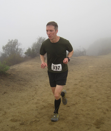
I was starting to think the Marin Headlands had followed me to Hollywood
(foggy foto by Chuck)
After a steep staircase-style ascent (up, level out for a few steps, up, level out for a few steps) of ~700ft over the first 1.4 miles, a brisk downhill ate up the rest of mile 2. Mile 3 comprised a gentler up and down, then transitioned briefly onto asphalt before returning to dirt on the Mulholland Trail. Thus began the first of three out-and-backs, as the trail skirted the ridge overlooking one of the many canyons in the area. Far below me to the southwest, the impenetrable cloud cover turned Hollywood appropriately enough into its own life-sized model of Gotham City, with foggy tendrils slinking between and obscuring the tops of high-rise buildings. And the thought crossed my mind: on almost any other day, this panoramic view would be striking.
This section appears like switchbacks on the course map, but more accurately the trail meanders back and forth along the ridge toward the turnaround point at mile 3.7. This allowed me to look ahead and see the caravan of runners I was chasing, though the turnaround remained out of view. The lead runners flew by in the opposite direction, and noting that five of the first ten runners who passed looked to be roughly my age, I kissed any hope I’d had of placing in my age group goodbye (as it turned out, there would be no age-group awards). But as my mind had wandered freely I’d fallen into a comfortable running rhythm, and before I knew it I’d reached and almost blown by the turnaround. Heading back the way I’d come, I fell into step behind a fellow who seemed to know every tenth runner or so coming the other way, doling out shout-outs of recognition and encouragement like a swiftly moving spectator.

Abandon all hope, ye who ignore the orange ribbons (photo and caption idea by Chuck)
After another brief transition on to asphalt and back on to dirt, we followed our first steep descent down Brush Canyon Trail toward the second turnaround. I desperately tried to keep pace with the cool kids in the downhill crowd, until an uphill blip at Bronson Canyon Park just before mile 6 slowed their momentum. Two women leisurely jogging in the opposite direction clapped their hands encouragingly at me and cried “Great job, looking good!” As I sputtered out an appreciative “thank you” I realized they were looking past me, and they ended their cheer with “you’re the third woman!” Apparently their support provided said female with a burst of energy, because at that moment she surged past me. I had just enough time to notice her impressively sculpted calves before we reached the third aid station at the mile 6.1 turnaround, beyond which lay the Batcave featured in the 1960s Batman TV series.
Quickly bat-turning past the aid station with a nod of thanks to the volunteers, I passed both the second- and third-place women and headed back over the uphill blip the way we’d come. With the most severe climb of the day looming, I wouldn’t be seeing either of them again before the finish. Shifting back into uphill gear I felt that familiar midrace energy lull wash over me, helped out by a gusty headwind and light drizzle. Also adding to my fatigue was the steady stream of energetic runners moving easily downhill in the other direction. Fortunately both the elements and my fatigue were short-lived, and my energy reserves kicked in as I passed several more runners on my way back up the Brush Canyon Trail ascent, which although lengthy (nearly 1½ miles) didn’t feel particularly steep.

Who woulda knew there was an Observatory and city skyline beneath all that fog? (photo by Chuck)
Reaching the top at ~mile 7.4, I followed the paved road until signs directed me back up the dirt on Eckert Trail. After running a very short distance uphill I heard sounds on the asphalt below, which ran parallel to my trail. Looking down I saw two runners – both of whom I’d recently passed – running along the asphalt in the same direction as me. “@!#?!” I muttered in frustration, channeling my inner Q*bert. The last thing I wanted was to lose the edge I’d gained from making great time up Brush Canyon Trail. I felt sure I’d correctly followed the signs up Eckert Trail, particularly since I’d followed another runner wearing a body-sized plastic-bag-turned-poncho. Then again, there were two runners on the asphalt below me who clearly felt they too were headed the right way. Jogging a few steps around the next bend, I saw no orange ribbon marking the trail ahead. So rather than run another step forward in what could have been the wrong direction, I slowly and reluctantly jogged back the way I’d come, resolving not to continue until I spotted someone else with a bib number following me.
Finally, about 20 seconds (which seemed like 5 minutes) later I got the reassurance I was looking for, in another bibbed runner coming up the trail. Turning quickly, my legs whirling in place like a Looney Tunes character, I punched the accelerator and tried to make up for lost time. Despite my frustration at the time lost, I did feel a slight sense of satisfaction at having built a comfortable lead over my closest pursuer.

Descending into the fog toward the Observatory down the Mt. Hollywood Trail (photo by Chuck)
Working my way toward mile 9 and the third out-and-back, it didn’t take me long to catch the plastic bag-clad runner (turns out she was a course monitor). Soon after that, as I closed in on the lead woman I looked up to see Chuck standing along the trail with camera poised… he’d run a mile up the trail to snap pictures. I was psyched to see him, but also disappointed that I couldn’t give him a better subject to shoot: me huffing uphill through a bank of fog wasn’t going to win him any Pulitzers.
Chuck saw me on my way, as I transitioned to the Mt. Hollywood Trail and began the descent toward the Griffith Park Observatory and the third turnaround. Both the Observatory across the canyon and downtown L.A. beyond it were shrouded by the persistent veil of fog that seemed to have leeched all color from the surrounding landscape. The course contained quite a few dogs walking their people, and at one point I quickly accelerated between two harried dog-walkers on opposite sides of the trail – one with five dogs, the other with four – before any multi-mutt nether-sniffing could break out.
Reaching the mile 10.4 turnaround just short of the Observatory, I started back up the trail and used this final uphill to pass the lead woman. Then I passed Chuck, who was waiting to take more pictures… luckily for Katie, her contract as my exclusive photographer isn’t up for renewal soon. At the top of the hill I transitioned to the Hogback Trail once again and headed downhill toward the finish, knowing this final ~1.5 miles would be a furious scramble as I tried to stay ahead of the fleet-footed lead female.

Heading down the Hogback Trail toward home, with lead female Kaitlin Lavin (wearing gray) in hot pursuit
(photo by Chuck)
Cruising downhill at a brisk pace, I hit a couple of short dicey stretches where I focused on vaulting from one dusty rock to another without wiping out. A fellow walking in the opposite direction clapped and urged me to “keep it strong!” before turning to his buddy and telling him, “My tattoo’s still itching.” As the terrain stabilized and my footing improved, I focused on maintaining pace while wondering whether I could reach the finish before the first female. This was going to be close….
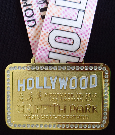
Or so I thought, until a navigational blunder with less than half a mile to go sent me flying by the sharp right U-turn that signaled the final stretch to the finish. The course signs here were unclear, and almost immediately I knew I’d made a mistake when I saw asphalt directly ahead of me. As I glanced back skeptically a Japanese woman holding a camera uttered a loud throaty sound, pointed down the trail and said simply, “That way.” I thanked her and, frustrated with myself and the questionable course markings, headed down the trail in the right direction. But not before I’d lost several valuable seconds as well as my slender lead over the first-place female. Down the Aberdeen Trail I followed her to Commonwealth Canyon Drive, where a sharp right turn led back on to the asphalt for the final 50-yard push. Enthusiastic cheers erupted ahead of me for what I assumed was her arrival at the finish line, and as I rounded one last curve I was amused to see Laura awaiting me with medal outstretched, which I gratefully accepted with a finish time of 1:48:00.
Just a few more yards ’til I can wear my INKnBURN shirt
(photo courtesy of Brian Cravens Photography)
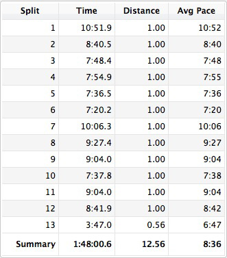
Glancing down, I saw disappointedly that my Garmin read 12.56 miles. I never object to running farther than 13.1 miles – the lone race I won, the 2009 Limantour Odyssey Half Marathon in Point Reyes, clocked in at a muscular 14.8 miles – but running less than 13.1 is a bummer, because it prevents you from claiming a PR (not that this would have been) and comparing your time to other half marathons.
First things first: I congratulated Kaitlin Lavin, who’d run well down the stretch and finished just ahead of me in winning the women’s division. Though as I’d expected, that final neck-and-neck downhill chase turned out to be academic: taking into account my back-of-the-pack start, I still finished ahead of her in the final standings based on chip time. Nonetheless it would’ve been nice to physically cross the finish line first, if for no other reason than in a race with 349 finishers, it would have been a major accomplishment to finish ahead of the entire woman’s field. Silly maybe, but motivation is as motivation does, and this unforeseen motivation of me vs. the women’s field had arisen organically during the race. More than anything, my imagined chase had kept me kicking hard up and down those final hills.

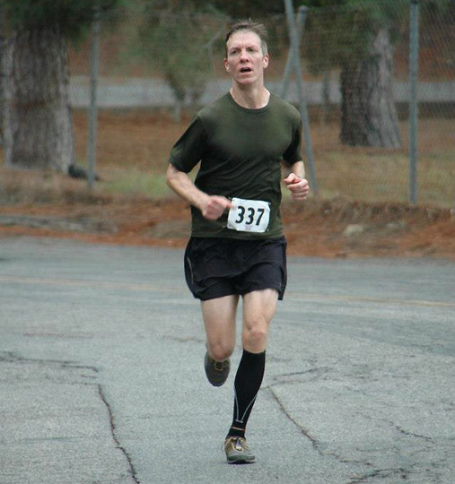
The final 20 yards on Commonwealth Canyon Drive
Appreciatively accepting a coconut water from the Naked Juice rep, I stretched out my right calf, which radiated a familiar “thanks for the workout, I’ll quiet down in a couple of days” tightness (which it did). Laura continued to award medals as I cheered on finishers and browsed the lunch provided by Keira, which included sandwiches, pasta and salad from Whole Foods. Although some runners were chowing down, my stomach would have preferred the usual post-race standbys of bananas, oranges and peanut butter pretzels. Instead, I sipped on my coconut water as Chuck rejoined me and introduced me to his friend and ultrarunner extraordinaire Michelle Barton. Unfortunately a knee injury had forced Michelle to sit out Griffith Park this year, although her 73-year-old father Doug had picked up the slack by winning the M(70-99) age group with a hotshot time of 2:34:22. Coincidentally, the same knee injury had sidelined her for the Moab Trail Marathon two weeks earlier, so I’d missed seeing her in Utah. But it was great to finally meet her, and here’s wishing her a speedy recovery and triumphant return to the race circuit very soon.
As the steady current of finishers slowed to a trickle we reclaimed Laura, leaving Keira to distribute medals to the remaining finishers. During our stroll back to the car, Laura told us that a couple of runners had not only bandited the race, but that each of them had also tried to collect a medal at the finish line. To “bandit” a race means to run it unoffically without paying the registration fee, a practice that in some circles is now treated as the racing equivalent of treason. Apparently, when Laura confronted each bandit and asked where his bib number was, the first chose the high road and handed back his medal whereas the second fellow chose poorly and actually ran off with his. Officers, bring in the medal-sniffing dogs!

Trying not to sweat on ultrarunner Michelle Barton
(photo by Chuck)
After registering for this race based almost entirely on its swag and SoCal location, I was pleased to discover that Griffith Park is in fact a bona fide trail race, meaning plenty of tough hills and scenic views (on a fog-free day). In the weeks leading up to the race, I’d even held out hope that I’d found a worthy challenger to rival Rocky Ridge as the rootinest, tootinest half marathon in California. But despite its significant hillage and elevation gain/loss of ~2,500ft (billed misleadingly as 5,100ft on the website), Griffith Park ain’t no Rocky Ridge, as evidenced by my 8:36/mile pace vs. 10:58/mile at Rocky Ridge. For now at least, Rocky Ridge remains The Big One on the California half marathon circuit.
So bottom line, I’m glad I ran the Griffith Park Trail Half. It’s a well-executed race on a fun course in a cool location, and with a medal that does its hometown proud. And thanks to my head-turning race t-shirt courtesy of INKnBURN, I can CRASHnBURN in my next several races and still look good doing it.
Maybe that makes me shallow… but in Hollywood it makes me fit right in.
PRODUCTION: Griffith Park is a relaxed, well-organized trail race on an excellent (albeit short) course. Trail races in general are more laid-back affairs than road races, and Keira did an admirable job of ensuring that all the key details were in order and that everything and everyone ran smoothly. Although I would invest in a bullhorn and forego the silent start next year… even a solitary “one minute to start!” announcement would have been appreciated. Based on the three criteria of course layout, race organization/execution and overall value, I’d still rate the Brazen Racing crew here in the Bay Area as my favorite trail racing outfit in the state.
In her pre-race email, Keira assured us the course would be “marked so well you could probably run with a blind fold on, and still find your way.” In general this was true, with orange ribbons lining the course, and enthusiastic and supportive volunteers on hand to direct runners at key transition points. But allowing for the fact that I often run like I’m blindfolded, I’d recommend clearer signage at a couple of places where multiple trails converge and where course markings might be (and were) overlooked, i.e. the fork up Eckert Trail at ~mile 8, and the final U-turn down Aberdeen Trail. Most importantly, the course should be extended by half a mile or the race renamed the Griffith Park Trail 20.2K.

Off the dirt and on the street: cool urban scenery in Hollywood
Credit to photographer Brian Cravens for making his collection of start- and finish-line photos freely available on the race’s Facebook page. Any photographer willing to share his photos without stamping his website URL or the word “PROOF” across them deserves a shout-out on a blog with upwards of a dozen readers. (UPDATE: After posting this, I learned that Keira actually paid the photographer to allow runners free access to all his photos, so let me appropriately redirect my shout-out… thanks, Keira! Posting free photos is a major bonus, and not many other races do it.)
For many trail runners, the major deterrent to running this race will be the substantial $120 registration fee (minus the online discount and plus the service fee). A sizeable chunk of this fee seemingly goes toward the INKnBURN race t-shirt, which as I may have already mentioned is very cool (and durable). So it may be possible to reduce the registration fee by offering a “no t-shirt” option during registration. However, given that the race is small (400 slots) and only in its second year, its popularity should only increase in the future, meaning the registration fee will likely increase as well. In which case, maybe next year a tiny portion of that fee could go toward post-race bananas, oranges and peanut butter pretzels?
But hey, these are minor grievances… at least there was no HEED at Griffith Park.
UPDATE: Keira promptly and thoughtfully responded to all my suggestions (see her comment below), which I think speaks to how committed she is to her job as race director and to growing the sport of trail running. Based on her feedback, I’ve no doubt the Griffith Park Trail Half will be an even better experience in 2013.

I would’ve posted sooner if my editor didn’t need so many naps
FINAL STATS:
November 17, 2012
12.56 miles in Griffith Park, Hollywood
Finish time & pace: 1:48:00 (first time running the Griffith Park Trail Half), 8:36/mile (official 8:15/mile pace based on a 13.1-mile course)
Finish place: 19/349 overall; 5/56 in M(40-49) age group
Race weather: foggy and cool (temperatures in the 50s) with intermittent light rain
Elevation change (Garmin Connect software): 2,420ft ascent, 2,431ft descent
(Garmin Training Center software): 2,897ft ascent, 2,815ft descent